
Distribution Map of Kalong (Flying Fox Bats) in Komodo National Park

Komodo National Park, widely known for its legendary Komodo dragon, hosts a remarkable diversity of wildlife — including flying fox bats, locally known as kalong, that play important ecological roles within the archipelago’s ecosystems. The Distribution Map of Kalong in Komodo National Park illustrates the key habitats and movement areas of these nocturnal mammals, particularly […]
Prey Species Distribution Map of the Komodo Dragon in Komodo National Park

The Prey Species Distribution Map of the Komodo Dragon (Varanus komodoensis) provides an important overview of the locations where key prey animals are found within Komodo National Park. This thematic map helps researchers, conservation managers, and ecotourism planners better understand predator–prey interactions in different parts of the park — including Loh Tongker, Loh Wau, Gili […]
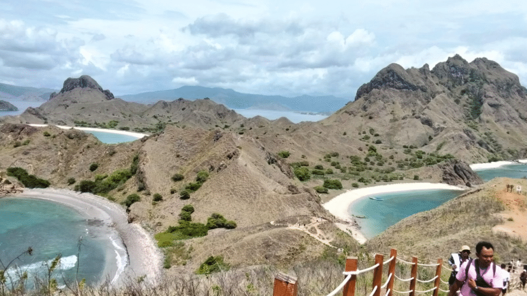
DDDT Document of Komodo National Park: Foundation for Visitor Capacity and Sustainable Management

The DDDT document of Komodo National Park is an important planning reference that supports the management of visitor flow and sustainable tourism in one of Indonesia’s most iconic conservation areas. It assesses the carrying capacity and visitor capacity of key trekking routes and popular visitor sites to strike a balance between ecological protection and tourism […]
Ecology, Population, Reproduction, and Spatial Dynamics of Komodo Dragons in Komodo National Park

The Final Report CRES with ISBN is a comprehensive scientific publication summarizing key research findings on the ecology, population dynamics, reproductive biology, and spatial behavior of the Komodo dragon (Varanus komodoensis) in Komodo National Park, Indonesia. This report covers results from field research conducted over several years as part of a long‑term study aimed at […]
Dive Map of Komodo National Park: An Underwater Paradise

Komodo National Park is not only famous for its terrestrial wildlife like the Komodo dragon but also ranks among the world’s most spectacular scuba diving destinations. Located in the heart of the Coral Triangle, its waters are rich in marine biodiversity, vibrant coral reefs, and dramatic underwater topography — making it a must-visit for diving […]
Land Cover Map of Komodo National Park, Understanding the Park’s Landscape and Vegetation

Komodo National Park is one of Indonesia’s most important conservation areas, known not only as the natural habitat of the Komodo dragon (Varanus komodoensis) but also for its unique landscapes and vegetation types. One of the essential tools for managing and planning this area is the Land Cover Map, which depicts the distribution of different […]
Land Cover Map of Komodo National Park

The Land Cover Map of Komodo National Park is one of the key spatial mapping tools provided on the official Komodo National Park mapping portal. It displays the distribution of different land cover types within the protected area, helping park managers understand the variety of ecosystems present in both terrestrial and marine parts of the […]
Yellow‑crested Cockatoo Monitoring Map at Komodo National Park
The Yellow‑crested Cockatoo Monitoring Map is a specialized wildlife monitoring map featured on the official Komodo National Park mapping portal. It displays key observation points and population monitoring sites for the Yellow‑crested Cockatoo (Cacatua sulphurea occidentalis) within the park. These monitoring efforts help conservation staff track and manage one of the key bird species found […]
Final Report CRES with ISBN – A Comprehensive Scientific Study on the Komodo Dragon (Varanus komodoensis)

The Final Report CRES with ISBN is a scientific document presenting an in-depth study of the population ecology, reproduction, and spatial behavior of the Komodo dragon (Varanus komodoensis) within Komodo National Park, Indonesia. 📌 Report Overview This report focuses on several key biological and ecological aspects of the Komodo dragon, the world’s largest lizard species […]
Komodo National Park Authority (BTNK) 2021 Kaleidoscope, Key Highlights and Achievements

The year 2021 marked an important period for the Komodo National Park Authority (BTNK) in managing one of Indonesia’s most iconic conservation areas—Komodo National Park—amid ongoing challenges including the global COVID-19 pandemic and evolving tourism dynamics. 🦎 1. Enhancing Ecotourism Services and Guide Training In late 2021, BTNK collaborated with the Labuan Bajo and Flores […]