
3 Days Shared Komodo Trip with Kanhaloka – Explore Komodo National Park in Comfort

The 3 Days Shared Komodo Trip with Kanhaloka is a highly recommended luxury tour designed for travelers who want to experience the best of Komodo National Park with comfort, adventure, and stunning natural scenery. This 3-day, 2-night shared liveaboard journey departs from Labuan Bajo every Friday and showcases the iconic islands, beaches, wildlife, and underwater […]
3D2N Komodo Tour with Zada Nara Liveaboard: A Deluxe Sea Adventure in Komodo National Park

If you’re dreaming of an unforgettable journey through one of Indonesia’s most spectacular natural playgrounds, the 3 Days 2 Nights (3D2N) Komodo Tour with Zada Nara Liveaboard offers just that. This deluxe sailing adventure departs from Labuan Bajo and takes you deep into the heart of Komodo National Park, combining scenic island visits, wildlife trekking, […]
Shared Komodo Tour 3D2N with Deluxe Boat NK Jaya

A 3-day, 2-night shared boat adventure exploring Komodo National Park — perfect for travelers who want a mix of nature, wildlife, snorkeling, hiking, and scenic beaches. Overview of the Package The Shared Komodo Tour 3D2N with Deluxe Boat is a group tour departing from Labuan Bajo (East Nusa Tenggara, Indonesia). The tour runs every Monday […]
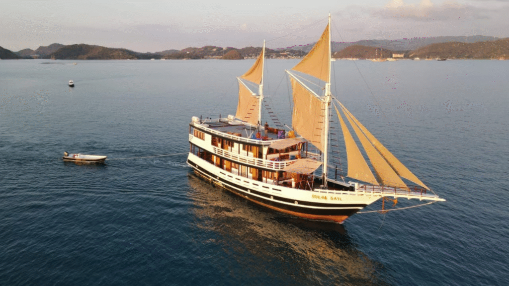
Sail Komodo 3D2N with Gandiva Liveaboard — Luxury Phinisi Cruise in Komodo National Park

The Sail Komodo 3 Days 2 Nights with Gandiva Liveaboard is a premium shared luxury boat tour that departs from Labuan Bajo, Flores, Indonesia. This itinerary offers an unforgettable 3-day journey through the breathtaking landscapes, pristine beaches, and rich underwater ecosystems of Komodo National Park aboard the elegant Gandiva Phinisi sailing vessel. Tour Overview The […]
Komodo Padar Tour Named Best Boat Rental in Labuan Bajo

Komodo Padar Tour Named Best Boat Rental in Labuan Bajo Labuan Bajo, Indonesia — Komodo Padar Tour operator based in Labuan Bajo, has been officially recognized as the top boat rental agency in Labuan Bajo by international travel review platforms and media outlets. This prestigious accolade highlights Komodo Padar Tour commitment to delivering exceptional service, […]
Top 10 Recommended Boats in Labuan Bajo
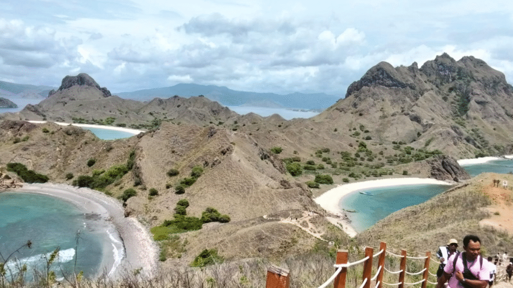
Labuan Bajo is much more than just the gateway to Komodo National Park — it’s also one of the best places in Indonesia to enjoy a sailing trip through some of the most stunning islands and marine environments on Earth. Choosing the right boat can make your trip unforgettable, whether you’re looking for luxury, adventure, […]
Land Cover Map of Komodo National Park, Understanding the Park’s Landscape and Vegetation

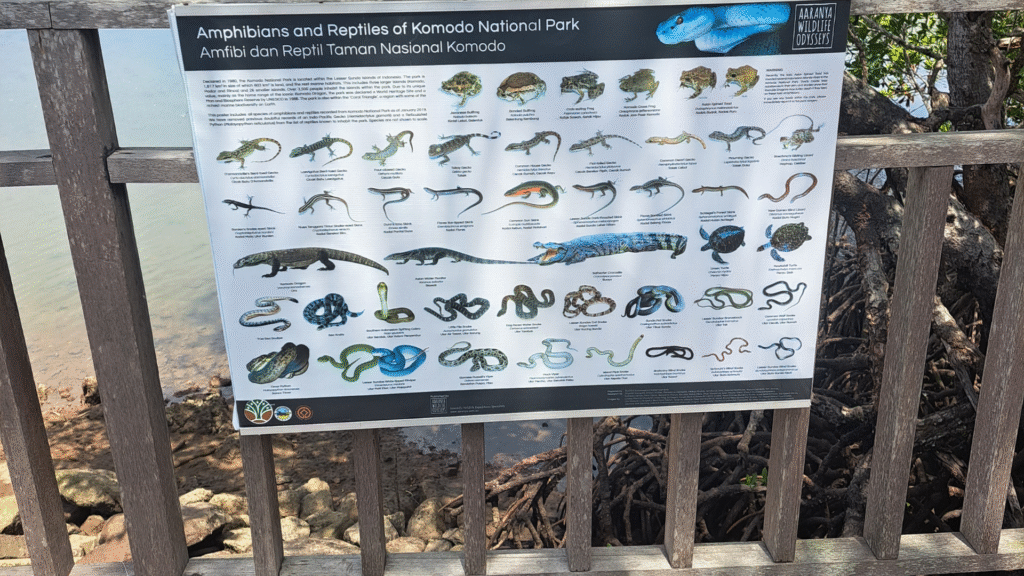
Komodo National Park is one of Indonesia’s most important conservation areas, known not only as the natural habitat of the Komodo dragon (Varanus komodoensis) but also for its unique landscapes and vegetation types. One of the essential tools for managing and planning this area is the Land Cover Map, which depicts the distribution of different […]
Yellow‑crested Cockatoo Monitoring Map at Komodo National Park
The Yellow‑crested Cockatoo Monitoring Map is a specialized wildlife monitoring map featured on the official Komodo National Park mapping portal. It displays key observation points and population monitoring sites for the Yellow‑crested Cockatoo (Cacatua sulphurea occidentalis) within the park. These monitoring efforts help conservation staff track and manage one of the key bird species found […]
Introduction to Mangroves in Indonesia: Understanding an Important Coastal Ecosystem
The Introduction to Mangroves in Indonesia Guide is a handbook that provides basic information about mangrove forests in Indonesia, including their habitats, distribution, benefits, and species identification. This guide was published to help conservationists, environmental managers, and interested members of the public learn more about mangrove ecosystems in Indonesia. What Are Mangroves? Mangroves are coastal […]