
Flores & Komodo Tour – 7 Days / 6 Nights

Start: Ende or Maumere (Central Flores)Finish: Labuan Bajo (West Flores)Price: Available on request (depends on season & group size) 📌 Tour Overview Explore the natural wonders and cultural highlights of Flores Island combined with the extraordinary beauty of Komodo National Park. This 7-day journey brings you from volcanic crater lakes and traditional hill villages to […]
Flores Land Tour Indonesia – 7 Days / 6 Nights

Tour Name: Flores Land Tour IndonesiaOperator: KomodopadartourDuration: 7 Days / 6 NightsStart & End: Labuan Bajo → Ende or Maumere (can also be done in reverse)Tour Type: Comprehensive Flores Island overland adventurePrice: Price per person upon request (varies by season and group size) Detailed Itinerary Day 1 – Labuan Bajo → Denge → Wae Rebo […]
Komodo national park shore excursion tour

The Komodo National Park shore excursion tour is designed for travelers arriving by cruise ship who want to fully experience the wonders of Komodo National Park in a single day. This shore excursion blends wildlife encounters, scenic nature walks, and optional beach relaxation for an unforgettable adventure on one of Indonesia’s most iconic islands. Overview […]
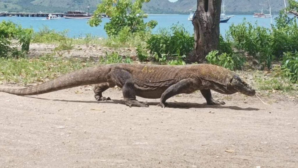
Komodo cruise handling with safe return to ship

If you’re visiting Komodo National Park on a cruise, the Komodo cruise handling with safe return to ship shore excursion offered by Komodopadartour is a perfect choice for travelers who want a memorable wildlife and nature experience in a short time. This tour focuses on observing the iconic Komodo dragons in their natural habitat and […]
Village Distribution Map Within Komodo National Park
Komodo National Park is not only a globally renowned conservation area for its iconic Komodo dragons and spectacular marine biodiversity — it is also home to human settlements that have coexisted with nature for generations. The Village Distribution Map within Komodo National Park shows where people live inside the protected area, highlighting the social and […]
DDDT Document of Komodo National Park: Foundation for Visitor Capacity and Sustainable Management

The DDDT document of Komodo National Park is an important planning reference that supports the management of visitor flow and sustainable tourism in one of Indonesia’s most iconic conservation areas. It assesses the carrying capacity and visitor capacity of key trekking routes and popular visitor sites to strike a balance between ecological protection and tourism […]
Zoning Map of Komodo National Park: Balancing Conservation and Sustainable Use

The Zoning Map of Komodo National Park shows how this globally significant conservation area is strategically divided into management zones to protect its unique biodiversity — including the Komodo dragon — while allowing sustainable use such as ecotourism and traditional community activities. This zoning system covers both terrestrial and marine environments within the park. 🗺️ […]
Land Cover Map of Komodo National Park, Understanding the Park’s Landscape and Vegetation

Komodo National Park is one of Indonesia’s most important conservation areas, known not only as the natural habitat of the Komodo dragon (Varanus komodoensis) but also for its unique landscapes and vegetation types. One of the essential tools for managing and planning this area is the Land Cover Map, which depicts the distribution of different […]
Land Cover Map of Komodo National Park

The Land Cover Map of Komodo National Park is one of the key spatial mapping tools provided on the official Komodo National Park mapping portal. It displays the distribution of different land cover types within the protected area, helping park managers understand the variety of ecosystems present in both terrestrial and marine parts of the […]
Turtle Monitoring Map at Komodo National Park

The Turtle Monitoring Map is part of the Monitoring Maps section on the official Komodo National Park mapping portal, which supports conservation and wildlife monitoring activities in the park. This map specifically visualizes data related to sea turtle monitoring within the protected area. This map is a component of the park’s spatial information system used […]